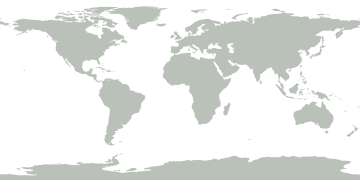
Togo argues map projections shape how nations perceive global geography
Togo argues map projections fundamentally influence how the world perceives geography and geopolitical relationships.
Event / Geopolitics
UN General Assembly adopts resolution promoting Equal Earth map projection to replace Mercator projection. Resolution passes 164-1 with US as sole dissenter. Equal Earth projection provides more accurate representation of Africa, Latin America, and South Asia. Initiative led by Togo and African Union with French co-sponsorship. France officially adopts Equal Earth projection.
2026-09-05 to 2026-11-07 · UTC publication dates
Coverage begins 5 Sept, 09:45 UTC
Follow the documented timeline or explore the related reporting.
The United States voted against the UN resolution on map projections. US representative Yaryna Ferencevych stated that resolutions promoting the ideological agenda of changing 16th-century cartographic projects hinder the UN's work and contribute to loss of institutional credibility. She argued the UN should focus on genuine issues of international peace, prosperity, and relations between countries rather than debating historical cartographic projects, and called on countries to exercise good sense by rejecting the text.
The Mercator projection, developed by Gerardus Mercator in the 16th century for maritime navigation, artificially enlarges territories at high latitudes while shrinking equatorial and tropical regions. This cartographic distortion causes Africa to appear significantly smaller than it actually is—approximately one-fourteenth of its real size relative to the Arctic and high-latitude regions. The Mercator projection similarly underrepresents Latin America and South Asia, perpetuating a geographically unbalanced view of the world.
The UN General Assembly adopted a resolution on Friday promoting the Equal Earth map projection as an alternative to the Mercator projection. The resolution was sponsored by Togo and the African Union, with France as a co-sponsor. It passed with 164 votes in favor, 1 vote against (United States), and 6 abstentions. The resolution encourages international organizations and UN member states to use Equal Earth representations in their cartographic materials.
The Equal Earth map projection corrects the geographic distortions of the Mercator projection by providing proportionally accurate representations of all continents and regions. This projection enlarges Africa, Latin America, and South Asia to their correct relative sizes while reducing the apparent size of territories at higher latitudes, including Europe, Russia, and North America. The Equal Earth projection maintains directional accuracy while presenting a more scientifically rigorous view of global geography.
France announced it would officially abandon the traditional Mercator projection in favor of Equal Earth representations. French Foreign Minister Jean-Noël Barrot, speaking at the Sorbonne on Friday, stated that correcting a cartographic representation that distorts reality constitutes an act of truth. Barrot characterized France's support for the resolution as consistent with French efforts to defend its own reading of international relations against simplified narratives, including debates over the Global South versus the collective West and perceptions of European decline.
Robert Dussey, Foreign Minister of Togo, stated that maps shape human understanding of the world and influence education, imagination, and collective perceptions. He argued that distorted cartographic representations, transmitted across generations, perpetuate erroneous views and are fundamentally a matter of cognitive justice, the dignity of peoples, and historical memory. Dussey emphasized that the resolution is not targeted at any specific nation or cartographic tradition, but is guided by a universal ambition to promote knowledge based on scientific rigor, respect for truth, and equal dignity of all peoples.
Togo argues map projections fundamentally influence how the world perceives geography and geopolitical relationships.
Mercator projection distorts regions; Equal Earth offers proportionally accurate alternative.
UN adopts Equal Earth map projection; US opposes while France supports.